Available with Spatial Analyst license.
Overview
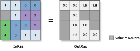
Calculates the inverse cosine of the pixels in a raster.

Notes
In mathematics, all trigonometric functions have a defined range of valid input values, called the domain. The output values from each function also have a defined range. For this tool, the domain and range are as follows:
- Domain: -1 ≤ [in_value] ≤ 1
- Range: 0 ≤ [out_value] ≤ pi
The input values to this tool are interpreted as unitless.
The output raster is always a floating-point type, regardless of the input value type.
The output values from this tool are in radians. If degrees are desired, the resulting raster must be multiplied by the radians-to-degrees conversion factor of 180/pi, or approximately 57.296.
For further assistance, a procedure to follow and some examples of converting output from radians to degrees are available.
Parameters
| Parameter name | Description |
|---|---|
Raster | The input for which to calculate the inverse cosine values. |
Extent Type | Choose which extent should be used in the output raster:
|
Cellsize Type | Choose which cell size to use in the output raster. If all the input cell sizes are the same, all the options will yield the same results.
|